Spatial Distribution of Patients in the Metropolitan Area of São Paulo Attending a Public Tertiary Cardiovascular Referral Hospital According to Diseases of the Circulatory, Respiratory, Endocrine, and Neoplastic Systems
Abstract
Background
The spatial distribution of patients according to clinical characteristics, using geoprocessing techniques, enables the identification of disease clusters within a studied population. This approach supports the development of targeted interventions directed toward specific risk groups.
Objectives
To investigate geographical clusters of diseases of interest among patients attending a public tertiary hospital and to characterize their spatial distribution across the metropolitan area of São Paulo.
Methods
Based on the results of a previous study, two disease groups were defined: one representing the main diseases identified at the first hospital visit and another representing the main underlying causes of death. A detailed description is provided in the . Disease density was calculated by dividing the frequency of cases within each disease group by the population of each city/district and multiplying the result by 100,000 to enhance data visualization. Spatial data were subsequently analyzed and mapped to illustrate the spatial patterns and relationships identified in the study.
Results
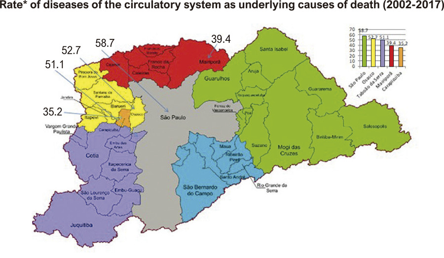
Osasco and Taboão da Serra showed the highest density of underlying causes of death related to diseases of the circulatory system. Additionally, 12 cities/districts located at the borders of the study area showed no recorded neoplastic diseases.
Conclusions
Vargem Grande Paulista showed the highest case density for neoplasms as underlying causes of death and comorbidities. Notably, Embu das Artes, a city recognized for its extensive green areas, showed the highest density of diseases of the respiratory system.
Images
Image gallery fullscreen viewer
Comments are moderated by the editorial team before publication. Discussions should be evidence-based and use scientific language. Conflicts of interest should be declared.